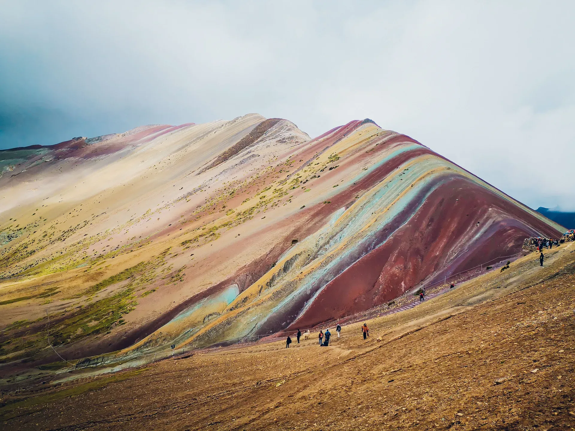
Parallel stripes of fuchsia, turquoise, and gold cut across a 5,200-meter peak in the Peruvian Andes. Vinicunca emerged from beneath melting glaciers to reveal a 24-million-year-old geological anomaly.
Parallel bands of fuchsia, turquoise, lavender, and gold streak across the high Andes of Peru's Cusco region. Vinicunca, widely known as Rainbow Mountain, stands at 5,200 meters above sea level near the snow-capped Ausangate glacier. The extreme altitude means the air holds half the oxygen found at sea level. Hikers face freezing morning temperatures and intense midday ultraviolet radiation to view the exposed mineral ridges.
The mountain transformed from an obscure glacial path into a major economic driver for local Quechua communities between 2011 and 2014. Heavy rains from November to April turn the steep dirt trails into hazardous mudslides, occasionally forcing complete road closures. Clear blue skies from May to October provide the safest trekking conditions and the sharpest contrast for the colorful sediment layers.
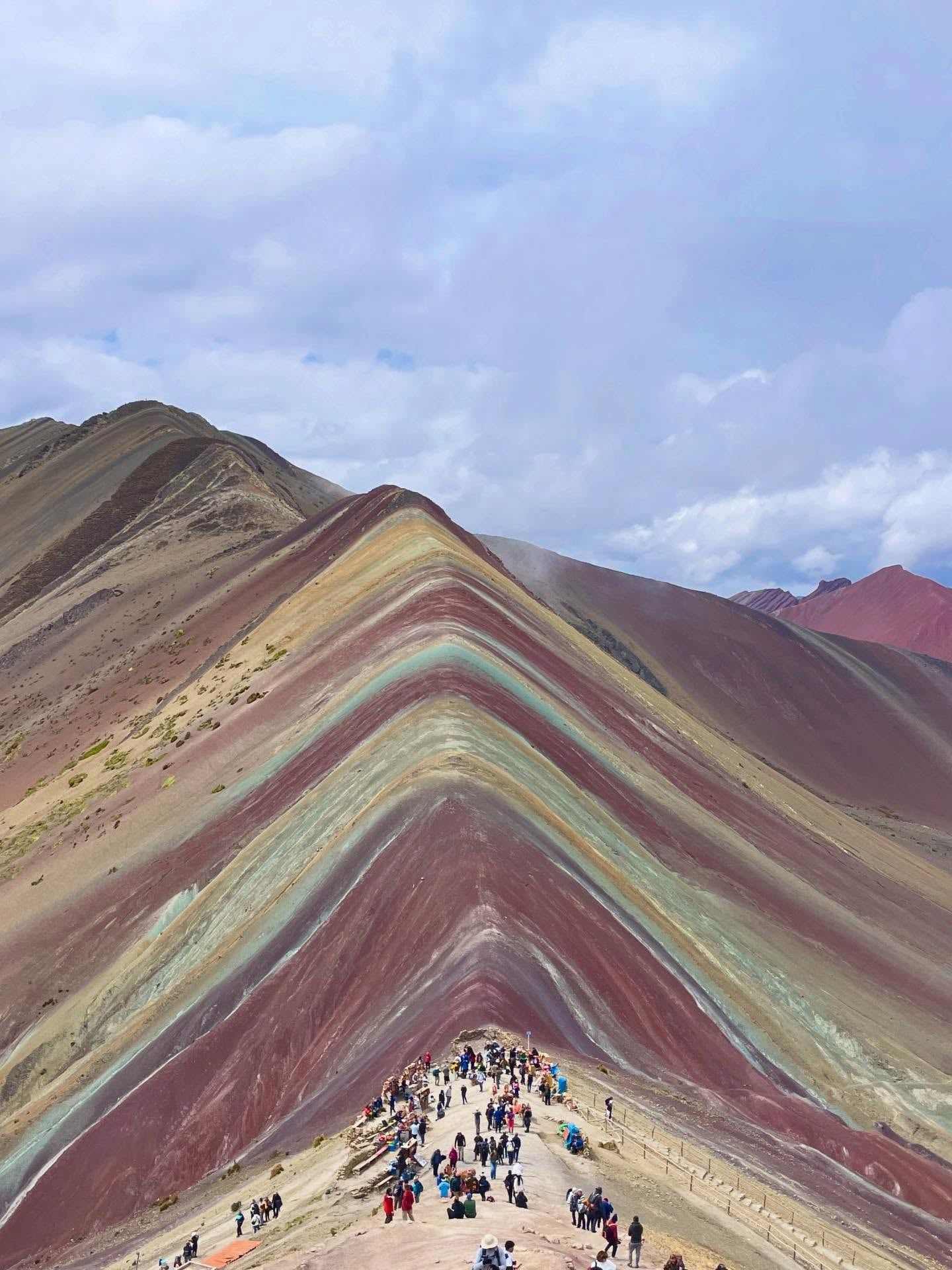
Reaching the summit requires a 140-kilometer drive from Cusco followed by a strenuous 1.5 to 2-hour ascent starting at 4,600 meters. Visitors who struggle with the thin air often rent horses from local herders for S/ 50 to S/ 80 to cover the first two-thirds of the route. The final 60 meters of elevation demand a steep, unassisted climb to the 5,046-meter upper viewpoint. From this rocky platform, the entire striped ridge stretches toward the horizon, framed by the massive white peaks of the Vilcanota range.
Thick ice and snow concealed Vinicunca for centuries. Quechua merchants utilized the lower slopes as a segment of the Qolla Ñan trading route, moving goods between Puno and Paucartambo. The mountain itself remained largely undocumented by outsiders, hidden beneath the freezing alpine environment of the Vilcanota range. Local herders grazed alpacas and llamas in the surrounding valleys, maintaining a quiet pastoral existence far from commercial tourism. The harsh conditions kept human settlements in the lower elevations, leaving the high passes exclusively to transient traders and native wildlife.
Global warming accelerated the melting of the Andean glaciers throughout the late 20th and early 21st centuries. As the ice retreated, the 24-million-year-old mineral deposits saw the sun for the first time in modern history. Mountaineers exploring the Ausangate circuit noticed the distinct bands of red, yellow, and turquoise rock. Word of the multi-colored peak spread among trekking communities, prompting local residents to investigate the sudden interest in their high-altitude terrain. Photographs of the exposed ridges began circulating on social media, accelerating global curiosity.
Residents of the Cusipata and Pitumarca districts recognized the economic potential of the exposed geology. Between 2011 and 2014, community members carved a 9-kilometer dirt and gravel trail into the mountainside to facilitate access. They established checkpoints, built rustic toilet facilities, and organized horse rental services for visitors struggling with the 4,600-meter starting altitude. By 2016, commercial tour operators in Cusco began running daily buses to the trailhead. The sudden influx of capital allowed these remote villages to invest in basic infrastructure and education.
The site now receives up to 1,500 daily visitors during the peak dry season from May to October. This rapid influx of foot traffic puts pressure on the fragile alpine ecosystem. Local guardians actively patrol the route to enforce environmental preservation, requiring tourists to stay strictly on designated paths. Unregulated budget agencies occasionally scam tourists by switching them to unsafe transport. Travelers must verify official passenger lists before boarding a bus in Cusco to ensure they travel with licensed, oxygen-equipped operators.
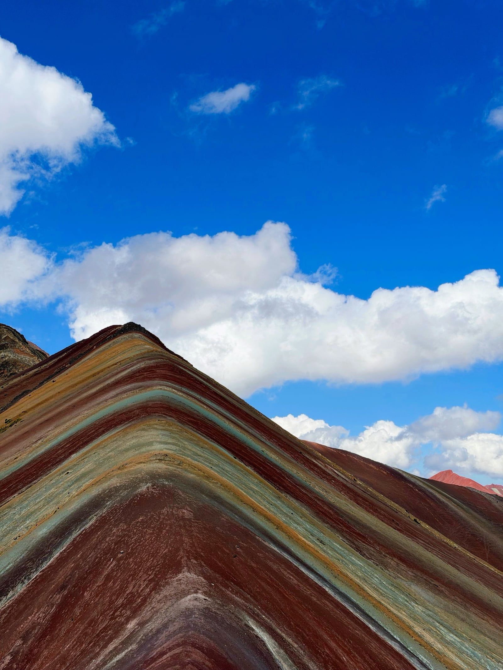
Sedimentation during the Cretaceous period laid down the foundation for Vinicunca's distinct appearance 75 to 63 million years ago. Layers of sandstone, halites, gravel, and limestone accumulated in distinct bands across the landscape. Tectonic shifts from the Nazca plate later forced these flat deposits upward, tilting the strata into steep, parallel ridges. Wind erosion and chemical sulfation then altered the pigmentation of the exposed rock, creating the sharp color contrasts visible today.
The specific mineral composition dictates the color of each stripe. Iron oxide produces the deep fuchsia and rust-red sections, while iron sulfide generates the bright gold and yellow bands. Chlorite and copper sulfate mix to form the turquoise and lavender streaks. These colors shift in intensity based on the time of day and weather conditions. Direct sunlight during the dry season between June and August illuminates the minerals, while thick fog in February can completely obscure the mountain.
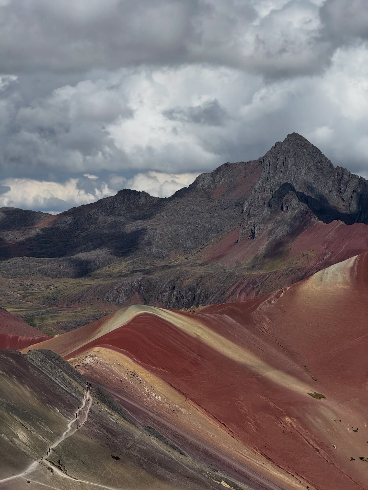
The surrounding ecosystem consists of a harsh, high-altitude alpine environment. Strong winds whip across the exposed ridges, dropping temperatures below freezing before dawn. Herds of native vicuñas, llamas, and alpacas graze on the sparse ichu grass that clings to the lower slopes. Hikers who extend their trek by one hour can reach the nearby Red Valley. This massive canyon of intense rust-red clay offers a stark, monochromatic contrast to the main peak and requires an additional S/ 10 to S/ 30 entrance fee at a separate checkpoint.
Andean communities revere Vinicunca as a sacred 'Apu', a protective mountain spirit that watches over the local population. This spiritual framework connects the physical landscape directly to Pachamama, the Quechua concept of Mother Earth. Local guardians perform regular rituals and leave offerings of coca leaves on the slopes to honor their ancestors. These ceremonies ask the mountain for safe passage for travelers and fertile grazing lands for their livestock.
The mountain sits along the traditional route of the Qoyllurit’i pilgrimage, the largest religious gathering in the Peruvian Andes. Tens of thousands of indigenous people hike into the freezing Vilcanota range each year to worship the mountain spirits and the Catholic image of the Lord of Qoyllurit’i. UNESCO recognized this syncretic spiritual center as Intangible Cultural Heritage of Humanity in 2011. The route passes directly through the valleys surrounding Vinicunca, cementing the area's status as a site of deep religious devotion.
Tourism has altered the economic reality of the surrounding villages. Families who previously relied entirely on subsistence farming and alpaca herding now manage access gates, operate food stalls, and guide pack horses. Visitors must pay the S/ 30 community entrance fee in cash directly to the local checkpoint. This direct payment system ensures the revenue stays within the district to fund infrastructure, maintain the rustic trail facilities, and support the families living at 4,000 meters above sea level.
Vinicunca remained completely covered by a thick glacier until the early 2000s when rising temperatures melted the ice cap.
The turquoise bands get their color from chlorite and copper sulfate, while iron oxide creates the deep red stripes.
At 5,200 meters, the air pressure provides hikers with only about 50 percent of the oxygen available at sea level.
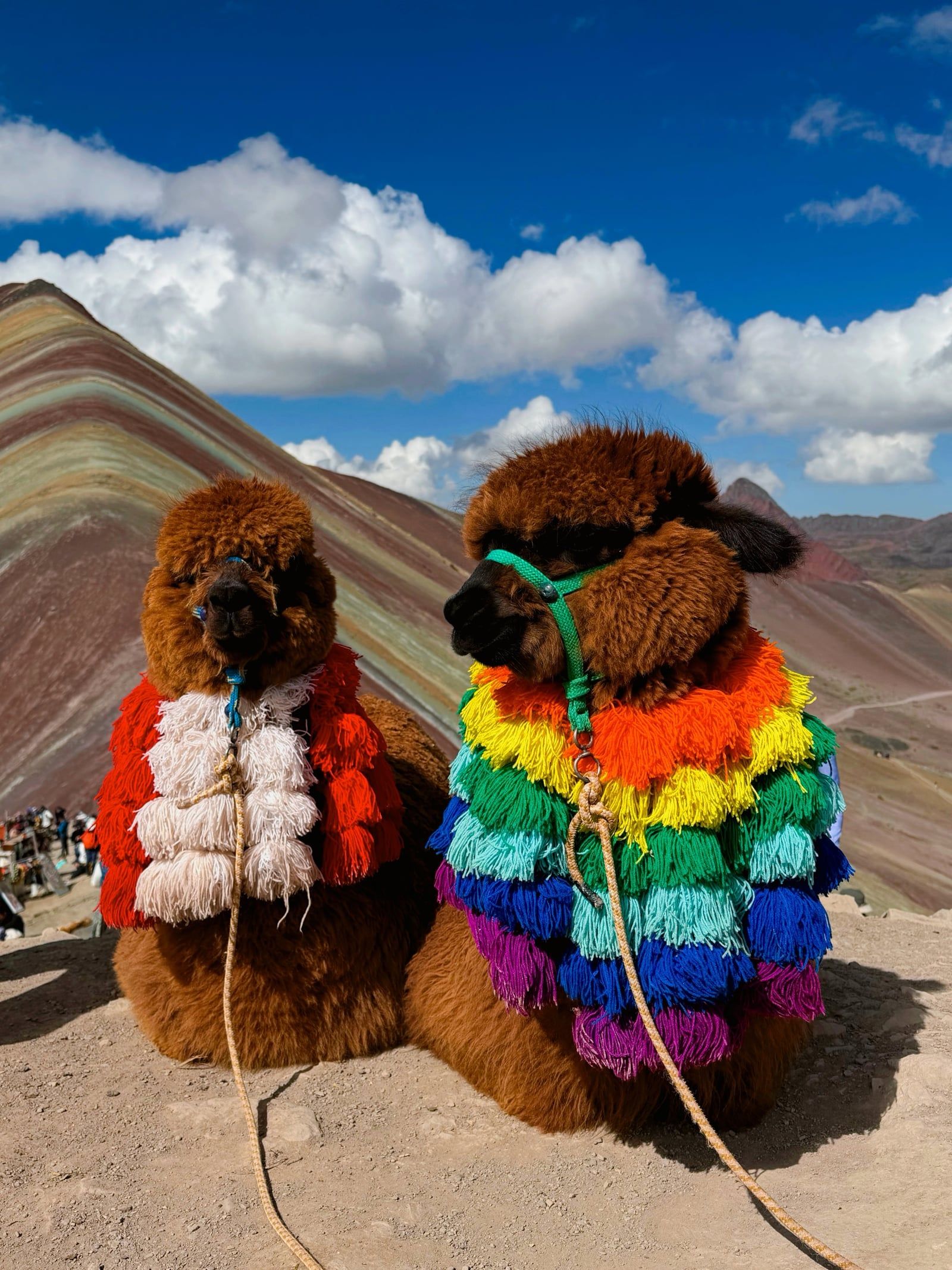
Local Quechua families graze their fluffy alpacas and llamas right alongside the main hiking trail.
Local authorities restrict heavy commercial filming equipment and drones to protect the peace of the alpine environment.
The summit drops below freezing at night but can reach hot, sunburn-inducing temperatures by midday.
A short extension hike leads to a massive canyon made entirely of rust-red clay, requiring a separate S/ 10 to S/ 30 fee.
The summit viewpoint sits at 5,200 meters (17,060 feet) above sea level. The hiking trail begins at 4,600 meters, requiring a strenuous 600-meter ascent in thin air.
Mineral sediments like sandstone, halite, and limestone settled in layers 24 million years ago. Tectonic plates pushed these layers upward, and chemical weathering turned them into distinct bands of red, yellow, and turquoise.
The round-trip trek covers 9.6 kilometers and takes about 3 to 4 hours to complete. The steep ascent usually requires 1.5 to 2 hours, depending on how your body handles the altitude.
Foreign visitors must pay a community entrance fee of S/ 30 (about $8-9 USD) at the local checkpoint. You must bring cash in Peruvian soles, as there are no card machines on the mountain.
The dry season from May to October offers the clearest skies and safest trail conditions. Heavy rains from November to April turn the paths into slippery mud and frequently obscure the mountain in thick fog.
Local residents rent horses for S/ 50 to S/ 80 one way. The horse carries you for the first two-thirds of the trail, but you must walk the final, steepest 30 minutes to the summit yourself.
Palccoyo Rainbow Mountain sits at 4,900 meters and requires only a 40-minute walk. It receives a fraction of Vinicunca's 1,500 daily visitors and features three distinct colored peaks.
Spend at least two to three days acclimatizing in Cusco before attempting the trek. Drink plenty of water, chew traditional coca leaves, and walk at a slow, deliberate pace.
Local communities maintain basic, rustic toilets at the trailhead and along the path. Using these facilities costs S/ 1, so keep small coins handy.
Independent travelers can take a public bus from Cusco to Cusipata or Checacupe, then hire a local taxi to the trailhead. This method costs between 250 and 350 soles and requires negotiating with the driver to wait for your return.
Browse verified tours with free cancellation and instant confirmation.
Find Tours